|

Avidyne FlightMax EX600
SLEW ! PAN ! ZOOM !
From 1999 to 2009 we operated a Colemill Baron
B-55, a well-equipped, nearly all-weather aircraft. It had an Avidyne EX500 MFD that was set up to read the GPS
flight plan, display instrument approach charts, traffic and NEXRAD weather, plus winds aloft and TAFs. We added the same EX500 display to our Blackhawk King Air, because we like the Avidyne so much. We operate a paperless cockpit with dual Jeppesen electronic charts, each chart display being on independent power.
I always found distant weather difficult to comprehend as the map scaling compressed the picture so much (on any WX receiver, for that matter). So, for years, we have asked Avidyne for a Slew Out / Zoom Down capabili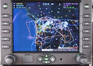 ty. In early January 2010, they delivered the first EX600 to us. As part of that upgrade, we changed our weather provider to WSI from XM. Which is better? What are the differences? ty. In early January 2010, they delivered the first EX600 to us. As part of that upgrade, we changed our weather provider to WSI from XM. Which is better? What are the differences?
Here we are on the ground in Virginia...having slewed the display to see the detail of "destination" weather in the Seattle area. Now we don't need distant-clarity on every flight, but when we do need it, it's REALLY NICE to have,
The flight plan in the navigator is from Virginia to Sondestromfjord Greenland via Halifax Nova Scotia and Goose Bay, Labrador.
But we are slewed all the way to the west coat of the US, simply because that was the only WX out there on this particular day, as you can easily see in the second image, below.
|
|
This device (showing WSI WX data, deliverd via the Sirius satellites) displays the METARS flags for the entire CONUS, Canada, Alaska, Mexico and Caribbean, the north coastline of South America, and the west coastline of Greenland. the flags offer a very fast visual snapshot of good vs. less-than-good WX.
Sure,
this flight plan is unrealistic. This one (
KS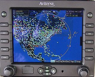 HD > CYHZ > CYYR > BGSF) was a test to see if Greenland METARS came in to the panel. They do indeed (west coast of Greenland only), fully decoded to English. HD > CYHZ > CYYR > BGSF) was a test to see if Greenland METARS came in to the panel. They do indeed (west coast of Greenland only), fully decoded to English.
Note that the EX600 has a much larger screen than the EX500. (The EX600 is exactly the same size as the MX-20 or GMX-200.)
The EX600's transflective display doesn't wash out in direct sunlight like normal LCD display do, so that's nice. Originally, in sunlight, it's a bit too dim for my liking; but by midsummer 2011, Avidyne had begun shipping a considerably brighter screen on the EX600s. |
|
But...let's assume that we were actually headed to Seattle. With weather like we saw above, we'd be interested in knowing more as we proceed to that destination. Right?
That's easy. Here's how the PAN/ZOOM works:
Having slewed to the area of interest once, thereafter we'd simply toggl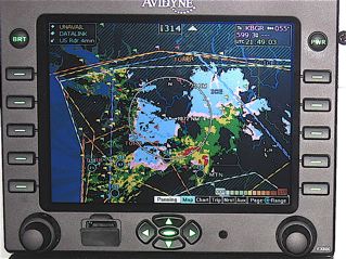 e back to that page (a single tap on the center Slew button) and then dial down the range. Just about how slick is that? In about 15 seconds, the display will revert to the aircraft's own location, but it will also remember the slewed-to area of interest and range setting, so it's easy to toggle back to Seattle any time we care to. e back to that page (a single tap on the center Slew button) and then dial down the range. Just about how slick is that? In about 15 seconds, the display will revert to the aircraft's own location, but it will also remember the slewed-to area of interest and range setting, so it's easy to toggle back to Seattle any time we care to.
...and this is a certified unit, not a portable. I have used most of the handheld portables and they are great, but I prefer this certified device with properly mounted external antennae. We do fly up north to the Arctic occasionally, and the much better external antenna location is worth it to me.
Another example: Here we are 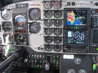 sitting on the ground in Virginia, looking at detailed Los Angeles CA weather. sitting on the ground in Virginia, looking at detailed Los Angeles CA weather.
Let's say we were headed there. We simply click that center slew button and take a peek westward every few hours or so.
It's so comforting to have such a detailed understanding of destination weather readily at hand.
|
Here's the north coastline of South America and all of Central America. We are still in Virginia, in the climbout as we head to south Florida up and over a huge snowstorm.
Isn't great information, just great?
IS XM "BETTER" THAN WSI? Does "Better" even matter?
IMPORTANTLY: I absolutely love BOTH products. In the final analysis, there is very little difference in that BOTH services will save a lot of lives and BOTH have made our flying so much easier...but I have come to believe that WSI's airborne NEXRAD (and the related WSI weather products) is a slightly better airborne service (at least, on the EX600 I operate.)
At the Beech Museum in May 2011 at Tullahoma TN, I listened with great interest to a Dr. David Strahle talk in-depth about "The Miracle of NEXRAD". I was generally impressed at the depth of Dr. Strahle's knowledge. I also thought he overlooked a few points.
By now, I have 800+ XM hours and 400+ WSI hours. Before I switched to WSI, I asked a number of questions of WSI. (Remember, I used to repair radars).
Dr. Strahle spoke mostly about individual radar sites and explained raw NEXRAD data; he talked less about the important matter of the mosaics we aviators use; ... and very little on the really important subject of how these mosaics are composed by the government and then tweaked (in various creative ways) by our several weather service providers.
He pointed out, correctly and importantly, that the vertical dynamics of a major storm need to be displayed prominently. I'd agree completely, but then he never mentioned the "Cell-Zits" in which both XM & WSI already deliver to us all of the features—more features, really—than he asks for and proposes be called the 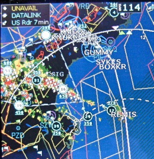 “Strahle Index” of vertical energy. Lightning Strikes give us the important hint that we are dealing with a very dynamic system. The CellZits, Cell Tops, Cell Direction, Cell Ground Speed, Hail Likelihood, and Lightning Strikes give us a very clear picture of where to go..or not! “Strahle Index” of vertical energy. Lightning Strikes give us the important hint that we are dealing with a very dynamic system. The CellZits, Cell Tops, Cell Direction, Cell Ground Speed, Hail Likelihood, and Lightning Strikes give us a very clear picture of where to go..or not!
Example. Here, we were “end running” a vicious line of weather; we are out over the Gulf, ~300+ people having just died from this line, the day before.
I thought that his omission of the manner in which WSI creates its mosaic was a bit misleading. So, a few days later, I talked to him at length; he agreed that a balanced presentation was important and he said he would change his future emphasis to say how very good BOTH products really are.
But here's why I like WSI NEXRAD a bit better than XM NEXRAD:
Base reflectivity provides a more accurate snapshot (think of an image taken in an instant) of the atmosphere; a snapshot gives us a better look at reflectivity gradients and shear which are the real concerns. The composite image is more like a time-exposure of a dynamic and rapidly moving subject; it’s blurry at the edges; by definition, it has to be blurry as it’s collected over a full scan sweep cycle of 10+ minutes. If Dr. Strahle’s patients were allowed to move around for ten minutes as he’s imaging their breasts, those images would be blurry, too. A medical technician immobilizes the patient for long scans and/or uses snapshots for the same reason that WSI does...to achieve precision imagery. But there is no way to immobilize a line of active weather.
Further, WSI does indeed depict radar returns well above the “Local Station’s Base-Sweep Height”. The important point is that WSI "mosaics" all of the overlapping NWS NEXRAD stations, such that for a given storm’s location, there are multiple base reflectivity values based on returns from different stations.
The center of the beam at ~ 30 NM is at ~2,000 ft AGL. Obviously, WSI depicts radar returns above that altitude. For example, a station at just 100 NM from the cell produces a base beam height of ~10,000-13,000 ft; it’s even higher when further away from the XMTR, of course.
The WSI mosaic software shows us the highest value of the base reflectivity from different stations; multiple stations are looking at the same storm at different heights. This is why they don't miss storms. I have yet to see a cell that WSI missed. In the very few cases where a CellZit appears alone with very little NEXRAD, that's a perfect example of the dymanic verticality measure that Dr. Strahe suggests be offered us. He's right about that, it seems to me, and that unstable verticality is already in-cockpit (from both XM & WSI) as CellZits and Lightning strikes.
WSI's meterologist told me last year--and my somewhat-experienced eyes believe--that the WSI methodology preserves the reflectivity gradient, which is important for interpreting the presence of shear and turbulence.
That makes sense to me; I have long disliked the blurry XM presentations, and early on I said it was “too-alarming”, far too much “Wolf!”, but I’d readily agree that it’s easy enough to ignore the full screen of green...except that we can’t see the NavData underlying the green, and I didn’t like that, because we have to turn it OFF.
Other than these omissions, Dr. Strahle offers a very good summary of NEXRAD, and how to use it. His is a lecture absolutely worth your time, if and when you get the opportunity. A few weeks later, a friend and I made a same-time, same place, same EX600 MFD comparison of the XM WX and WSI NowRad images. I'd love to know what you think of our study.
And come back next year! This technology is changing fast, improving monthly. All providers are getting better at delivering FABULOUS weather information services.
Any questions? just give me a call, or
click on the e-mail link below.
While you are here, have a look at our horse
teams, and carriages, or take
a tour of our farm in central Virginia.
|