APRIL 2005 - There is lots of good recent news!
As of April 2005 the Avidyne EX500 has been upgraded
to include on-board JeppView approach charts (called
CMax by Avidyne) and XM weather datalink from the
high-powered XM radio satellites. Over-the top
language—“Superb!” “Elegant!”
“Beyond unbelievably great!”—seems
appropriate as one describes his first reaction to
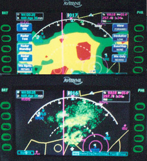
flying this IFR-certified Multi-Function Display (MFD).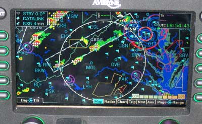 This image of XM WX was taken inside my hangar, with
engines off. In one glance, we can see the blue (good
WX) METAR flags, the threatening NEXRAD and watch
areas. The DC ADIZ is hard to miss, as well.
This image of XM WX was taken inside my hangar, with
engines off. In one glance, we can see the blue (good
WX) METAR flags, the threatening NEXRAD and watch
areas. The DC ADIZ is hard to miss, as well.
I have owned a Baron equipped with the Avidyne EX500 and OrbComm datalink for several years. Listening, recently, to other pilots complain about slowness of that OrbComm system, he thinks “How soon we forget!” Only two years ago, no such in-cockpit weather delivery technology existed at all for the general aviation market, yet we all—myself included—demand higher speed access to information. Whether it’s fair or not, that’s reality and Avidyne has responded. The XM WX feed is just extraordinary.
A word about the Avidyne folks: I have been flying for almost five decades. Never have I done business with a supplier that is as responsive as this team. From the sales team: quick responses. From my installing dealer: professionalism. From the support staff: fast, solid answers, including the occasional straight talk “We don’t know…but we’ll find out for you” and they almost always do. I could not be more pleased with a product or the team behind it. Some of the Avidyne software engineers are also instrument- rated pilots and it’s obvious that the people who wrote this computer code have flown a lot in the IFR system.
Indeed, while I have made a few minor suggestions to Avidyne, I did not think there was a whole lot of major improvement that the earlier EX500 needed. Wrong. This upgrade is major leap for Avidyne’s EX500 and is an exceedingly well-executed enhancement.
Upgrades
The upgrade (including CMax charts and XM WX datalink) requires both a thirty minute hardware upgrade—accomplished by our avionics shop—of a larger-capacity internal flash card and a software reset to support the new applications. The XM WX radio antenna must be installed on the top of the aircraft, and a HeadsUp XM receiver (FAA-certified) is installed to process the signals. That was easy enough to accomplish as the upgrade was accompanied by clear, well-documented instructions.
A pilot familiar with the EX500 will immediately
see a few really big improvements; the NEAREST LISTS
(airports, VORs, NDB’s, intersections, obstacles)
has always offered a list of airports close to the
PRESENT POSITION. The EX500 now offers a second list
of airports NEAREST TO DESTINATION. That’s really
good information to have in-cockpit when headed towards
an area of questionable weather, where an alternate
destination may be needed.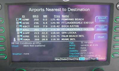
New on both of the NEAREST AIRPORT lists: each airport that has any published IFR approach is so indicated by a small chart symbol. Symbols with the letter “I” indicate that precision ILS approaches are available. Nice! That saves a lot of searching. In addition, with OrbComm satellite delivery (called Narrowcast by Avidyne), any of these airports near a METAR reporting station will be shown with graphical METARS, a tiny flag with varying colors representing the IFR/VFR summary weather conditions. That’s wonderfully helpful, but not new. However, with XM WX weather datalink installed, each of these stations will display a fully decoded METAR sequence.
Time of delivery? … about three minutes after engine start. Area covered? The plain-English METARS, NEXRAD, and boundaries of SIGMETS, AIRMETS, TFRs for the whole CONUS are delivered within that same three minutes. That gets a “Wow!”
The TRIP Page shows a few new features: on very long legs, the EX500 will calculate an intermediate WX waypoint every hundred miles or so, and will report the weather for a METAR station near that point. We used to have to trick the system to get that data, so this is a better, more elegant way. Of course the TRIP page still reports fully decoded METARS for each station in the flight plan. The datalink status portion of the TRIP page has been expanded, making it easier to check service and status here instead of having to go to the AUX pages. There are two datalink status pages: one for each datalink system.
GMT and Local Times are now correctly handled as 24 hour numerals. Thanks, Avidyne. Their previous date/time presentation used a non-aviation convention that displayed a 12 hour AM/PM time, including GMT as AM/PM. I hated it. The upgrade with its more conventional aviation presentation is far better.
A brief note in the POH indicates that a pilot using Narrowcast data delivery can differentiate between “hot” and “cold” SUA status while Broadcast (XM) delivery will offer Lightning strike data. This is all new stuff.
Charts
There is a new main page—CHART—on which is displayed a single approach chart, as chosen by the pilot. To display this chart, the pilot must choose which one she wants. Typically, the software nominates an appropriate airport along with its associated procedure charts.
APPROACH CHARTS: From this list
of charts, the aviator selects one approach procedure,
then zooms in and/or slews it around so as to see
the portion that is of interest. Each chart has four
sub-pages. 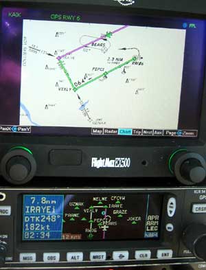 An
Approach charts shows 1: the Briefing strip 2: the
Plan view 3: the Profile view and 4: the Minima. Zoom
in on and slew each sub-page and it will stay at the
same zoomed-presentation she has chosen. Switch away
from the Chart page and come back, and it still looks
the same. That’s nice … as that means
fewer knobs to twist when she’s busy.
An
Approach charts shows 1: the Briefing strip 2: the
Plan view 3: the Profile view and 4: the Minima. Zoom
in on and slew each sub-page and it will stay at the
same zoomed-presentation she has chosen. Switch away
from the Chart page and come back, and it still looks
the same. That’s nice … as that means
fewer knobs to twist when she’s busy.
In addition—in the background—the related Airport Runway and Taxi chart is held in reserve, being loaded automatically with an associated instrument approach chart. On landing, after groundspeed drops below 50 knots, the Airport diagram then appears automatically on the Chart page (which must be manually selected—I’m happy to see, but only one twist—instead of changing away from the MAP page on its own,) and the ownship symbol tracks right down the remaining runway, then down the taxiways to the FBO. Pretty slick, and very helpful when arriving at an unfamiliar airport.
ZOOMING and SLEWING: All charts may be zoomed in and out, slewed left, right and up and down, and… they stay where you left them! That’s so nice. So, it is possible – after getting the ATIS, and long before landing – to anticipate the taxi route and to then zoom in to the appropriate airport area. Then the pilot returns either to the Map, Radar, TAWS, or Traffic pages, as needed. After landing, he flips back to the properly-zoomed Airport Chart, so there is no more busy-work adjusting to be done as we exit the runway.
Departure Charts: As one begins a flight, the reverse is true. The EX500 has always remembered its last position on shutdown. On wakeup, that position is still used to send out its initial request for NEXRAD WX within a 100 mile radius and it is now also used to pop up the Airport Diagram chart for use while taxiing out. On a strange airport, this is a wonderful feature.
XM WX Datalink Weather
OrbCom was an idea that worked pretty well, and still does, but the design of the low earth orbit and low-power satellite system is such that wide bandwidth is not available. To accommodate the massive datastream that a full CONUS dataset requires, Avidyne added XM WX delivery. That is accomplished with an account with XM which offers two levels of service: Aviator and Aviator Light. We chose the full Aviator service that includes lightning information from the National Lightning Detection Network.
Within seconds after startup the Lightning strikes
appear, followed immediately by nationwide NEXRAD.
Three minutes or so after startup, the plain-English
METARS, SIGMETS, AIRMETS, TFRs appear in-cockpit… for the entire CONUS. [NOTE: In August 2007, Avidyne upgraded its software. We now also have TAFs, Winds Aloft and Icing Levels, and Storm CellTops and cell path direction with likelihood of hail within a cell]. Thereafter, the weather information
refreshes about every six minutes or so, quire reliably,
with none of the datalink interruptions we used to
experience on the OrbComm links. 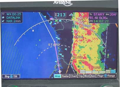 Quite
extraordinary, and wonderfully comforting on a day
with challenging weather systems like this one. It
is entirely possible to make this trip without in-cockpit
NEXRAD, but it was a no-sweat operation as we watched
this powerful frontal system -- even before takeoff
in Virginia, then during the next two hours southbound
-- and slipped around it in smooth air; we were totally relaxed. Note the 2 minute old NEXRAD
status and the lightning strike data overlaying the
NEXRAD.
Quite
extraordinary, and wonderfully comforting on a day
with challenging weather systems like this one. It
is entirely possible to make this trip without in-cockpit
NEXRAD, but it was a no-sweat operation as we watched
this powerful frontal system -- even before takeoff
in Virginia, then during the next two hours southbound
-- and slipped around it in smooth air; we were totally relaxed. Note the 2 minute old NEXRAD
status and the lightning strike data overlaying the
NEXRAD.
MultiLink, Narrowcast, and Broadcast: How does the aviator use these tools? Simply put, the best way to run this MFD in the CONUS is to let the high powered XM satellites blast data into it – as much as one wants to pay for. XM WX charges a flat fee and service is available at two levels. The user should probably leave the Multilink enabled, which really means that this “fee for data” service (paid to Avidyne) is sitting in the background doing not much (nor costing much), but if the XM datalink breaks down the Narrowcast link will pick up the slack. Narrowcast also offers text messaging and flight logging automatically, so if Narrocast is disabled, one loses that functionality.
Geographic Coverage. NEXRAD is limited to the CONUS and lower Canada, because of the locations of the NEXRAD ground radars. The EX500 will support a larger coverage area so if the NEXRAD Mosaic is ever expanded, the upgraded EX500 will display it without further upgrade.
A pilot flying into the Caribbean or Canada will want to have Multilink as all the non-CONUS data is delivered with that system. The vast majority of the Canadian populated area is covered by NEXRAD, but none is delivered by XM WX. Flights into lower Canada will need Multilink or Narrowcast if they want either NEXRAD or METARS. Full Canadian, Mexican, and Caribbean METAR coverage is available on Narrowcast. This is a huge increase in coverage area for the upgraded EX500 and a wonderful feature for pilots operating in these areas. I go both places often and have missed my on-board datalink service as soon as crossing either border. But don’t expect the two NEAREST airport lists to provide plain-English METARS outside of the CONUS; only the waypoints on the TRIP list will do that.
Text messaging: E-mail in the cockpit? Yes. Avidyne uses its two-way datalink to offer selected persons (the pilot chooses them) access to an Avidyne password protected website. Not limited to a single person, whoever has the key may send a (200 character maximum) e-mail which is delivered to the cockpit by the Orbcom satellites. The cockpit can reply back, with up to 30 characters. Messages like “We r late ETA KIAD 9 PM LCL” will become common. When a message arrives, The EX500 quietly prompts the pilot who can later read and reply to the text at his leisure, so as not to intrude on his flight operations. Authorized persons can also use the website to locate the airborne aircraft on Avidyne’s flight tracker.
Minor suggestions for further improvement:
This software is so elegantly done that there are darned few substantive suggestions one can make.
TRIP PAGE:
I do wish that two buttons on the Trip page -- the AIRPORT INFO and DISPLAY CHART buttons -- would nominate airports that meet the Airport selection criteria (runway length and surface) used, so sensibly, elsewhere. As the EX500 works now, the AIRPORT INFO button suggests the destination – or, in the case of a user-defined destination waypoint, the nearest airport to that waypoint - and DISPLAY CHART pops up charts for the airport with the nearest METAR reporting. Neither of these selections is constrained by the pilot-configured airport selection criteria, as they should be. Why? Because the nearest airport and nearest METAR source are not necessarily the same places, not do they necessarily match the aircraft’s runway requirements. When one gets in a plane with a 4000 foot runway requirement and notices a 2000 foot runway suggested by the EX500, this becomes a obvious area for improvement.